
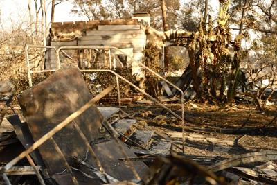
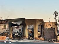
Scene from the Eaton fire in Altadena and Pasadena areas on January 10, 2025. (Gisselle Palomera/CALÓ News)
The deadly Eaton fire was 65% contained Friday while the death toll rose to 17 and more evacuation orders were lifted on the outskirts of the deadly burn area near Altadena and Pasadena.
Aided by cooler temperatures and calm winds, firefighters extended containment of the deadly Palisades Fire to 31% Friday, as some residents were being permitted to return to their homes in select neighborhoods.
"Containment continues to grow, and the fire is expected to stay within its current footprint," CalFire reported in a Friday morning update.
The Eaton Fire had burned 14,117 acres as of Thursday night, fire officials said. Containment was 45% Wednesday night.
On Thursday, firefighters continued mop-up operations and reinforced containment lines focusing on the challenging, steep terrain near Winters Creek along the northern flank of the fire, officials said. Infrared flights were conducted to identify any remaining hot spots in hard-to-reach areas with helicopters being used to extinguish the spots.
The Los Angeles County Medical Examiner's Office on Thursday reported 17 deaths tied to the Eaton fire, an increase of one from Wednesday. There are 24 active missing-person cases from the Eaton Fire, Sheriff Robert Luna said.
Mandatory evacuation orders remained in place for thousands of residents in the Eaton fire area, although on Thursday afternoon, residents along Canyon Crest Road into The Meadows east of El Prieto Road were permitted to return home.
Luna said Thursday he anticipates the bulk of the evacuation orders in the fire area will remain in place for at least another week, likely longer.
Los Angeles County Fire Department Chief Anthony Marrone said earlier that more than 7,000 structures are believed to have been destroyed or damaged - - many of them homes -- and nearly 40,000 structures were said to be threatened. Those numbers were expected to rise after further evaluation.
Damage assessments in the Eaton Fire area were about 92% completed as of Thursday morning. As of Thursday, 5,718 structures were officially listed as destroyed, and 679 were damaged.
Palisades fire
As of Thursday morning, the fire that erupted Jan. 7 had scorched 23,713 acres, according to Cal Fire. It was 21% contained Wednesday evening and 18% contained Tuesday evening, but crews were able to take advantage of favorable weather conditions to build containment in recent days, reaching 27% Thursday night and up to 31% Friday morning.
In addition to extending containment lines, crews spent much of Thursday searching for and knocking down smoldering hot spots within the burn area. Efforts were also underway to remove toxic substances and other hazardous materials to prepare burn areas for eventual repopulation.
Winds are expected to remain calm through the weekend, but another Santa Ana wind event is in the forecast for early next week.
At least 10 people have died in the fire, although authorities said they anticipate the number of fatalities to continue rising as crews begin sifting through the ash and rubble.
Los Angeles Police Department Chief Jim McDonnell said Thursday the department is investigating five missing-person reports in the Palisades Fire area. The Los Angeles County Sheriff's Department had seven active cases in areas near the Palisades Fire as of Thursday night.
At least 5,000 structures are believed to have been destroyed or damaged in the blaze that has been burning since Jan. 7. That number is also expected to rise as more assessments are done in the burn area.
The cause of the fire remains under investigation.
Authorities warned residents near the fire areas that air quality continues to be highly unhealthy. People were urged to suspend the use of leaf blowers, to stay inside with doors and windows closed as much as possible, and to wear masks if they do go outside.
The massive mandatory evacuation zone from fire stretches from the Pacific Ocean to the west, the San Diego (405) Freeway to the east, San Vicente Boulevard to the south and the Encino Reservoir to the north.
Most evacuation orders are expected to remain in place for at least another week, authorities said Thursday morning. On Thursday afternoon, however, residents were permitted to return home to select neighborhoods in the Palisades Fire area.
In areas within Los Angeles County Sheriff's Department territory, residents were allowed to return to the following zones:
-- TOP-U001: north of Topanga Canyon Boulevard and south of Mulholland Drive;
-- TOP-U002: north of Old Topanga Canyon Boulevard and south of Summit to Summit Motorway;
-- DRY-U026: north of Mulholland Highway and south of Stokes Canyon Road; and
-- RRC-U027: north of Red Rock Road and south of Calabasas Peak Motorway.
People will have to show proof of residency to enter the areas. Resident access will be through the intersections of Mulholland Highway/Old Topanga Canyon Road, Civic Center Way/Malibu Canyon Road, and Mulholland Drive/Topanga Canyon Road, according to the sheriff's department.
In areas within Los Angeles, residents were permitted to return home to the following zones:
-- LOS-Q0765: North of Standish, Mulholland Drive; south of Aldon Road; east of Escalon Drive; west of Hayvenhurst Avenue;
-- LOS-Q1118: North of Mission Canyon Road; south of Meadow Ridge Road, Hayvenhurst Avenue; east of Calvena Drive; west of Sepulveda Boulevard, Valley Meadow Place, Royal Oak Road;
-- LOS-Q0798: North of the San Diego Freeway; south of Mulholland Drive; Canyonback Road, Mulholland Drive; west of San Diego Freeway, Mulholland Drive;
-- LOS-Q0782B: North of Canyonback Road, Mission Dump Road; south of Park Lane Circle, Mulholland Drive, Sloan Drive; east of Canyonback Road; west of Sepulveda Boulevard;
-- LOS-Q0778A: North of Canyonback Road; south of Canyonback Road, Mission Dump Road; east of Canyonback Road; west of Canyonback;
-- LOS-Q0781A: North of Promontory Road, Mount Saint Mary's Fire Road; south of Canyonback Road, Mission Dump Road; east of Canyonback Road; West of I-405;
-- LOS-Q0782A: North of Getty Center Drive, Mount Saint Mary's Fire Road, North Bundy Drive; south of Promontory Road, Mount Saint Mary's Fire Road; east of Mount Saint Mary's Fire Road; west of I-405; and
-- LOS-Q0780: North of North Kenter Avenue, Greenock Lane; south of North Kenter Avenue, Sky Lane, Travis Street, North Tigertail Road; east of Access Road for Power Lines; west of Greenock Lane, Travis Street.
Residents returning to the areas will be required to show identification. Some of the homes in the areas being repopulated may not have power, as the Department of Water and Power is awaiting approval from fire authorities before re-energizing lines in the fire zone.






(0) comments
Welcome to the discussion.
Log In
Keep it Clean. Please avoid obscene, vulgar, lewd, racist or sexually-oriented language.
PLEASE TURN OFF YOUR CAPS LOCK.
Don't Threaten. Threats of harming another person will not be tolerated.
Be Truthful. Don't knowingly lie about anyone or anything.
Be Nice. No racism, sexism or any sort of -ism that is degrading to another person.
Be Proactive. Use the 'Report' link on each comment to let us know of abusive posts.
Share with Us. We'd love to hear eyewitness accounts, the history behind an article.